Snow, Glaciers, & Alpine Hydrology
Much of the original theory in glaciology came from work on alpine glaciers, mostly in Europe. This is partially because of their relative proximity to human civilizations, but also becuase until recently we thought that the polar ice sheets operated on millenial timescales, too long to be of immenent concern. It was only around the turn of the century that the glaciological community started to recognize key instabilities within the ice sheets that can be triggered much faster, on the order of decades to centuries. While alpine glaciers have since gotten less attention in terms of sea-level focused research publications and grant funding, they are still critical for water supply, temperature, and chemistry, especially in alpine environments.
Ice Dynamics
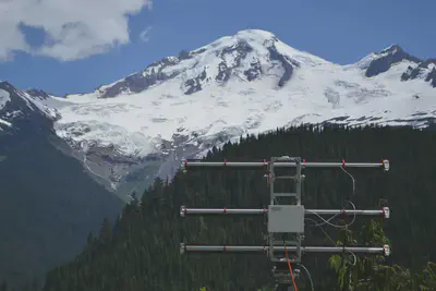
We study alpine glacier dynamics using various tools and techniques. As an example, we use a ground-based radar interferometer at the north face of Mt. Baker. We repeatedly scan the mountain face every 2 minutes for several days and by comparing the phase return between scans can tell how objects in the field of view are moving. This is much like the ApRES measurement described in Cryo Geophysics but many different reflections from across a range of azimuths.
In collaboration with Dr. Peter Neff of the University of Minnesota, we are surveying Combatant Col in preparation for an ice core to be drilled there in summer 2023. This is a radar survey which includes not only measurements of the ice geometry, but also repeat measurements to investigate a perennial firn aquifer and to understand how the ice is flowing.

Mass Balance
The United States Geological Survey (USGS) has a surveying outpost at four alpine glaciers, Sperry Glacier in Montana, Wolverine and Gulkana Glaciers in Alaska, and South Cascade Glacier in Washington. For decades, they have been tracking the mass balance, the amount of ice added by snow and removed by melting. Understanding how these USGS ‘benchmark’ glaciers are changing over decadal timescales is helping us understand the regional influence of climate change. Our research group at UW works in collaboration with scientists at USGS, including Dr. Caitlyn Florentine and others, doing field campaigns to collect data for surveying these glaciers, especially at our local South Cascade Glacier.
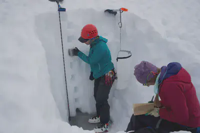
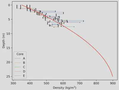
Measuring glacier mass balance is relatively simple. For inputs, we drill a snow core or dig a snow pit at the end of the winter season and measure the total depth as well as density through the column. Together, depth and density give us an input balance in units of snow water equivalent (SWE). For outputs, we drill a metal stake into the ice at the beginning of summer and observe how much it has melted out by the end. Again, this measurement will be in SWE. Then the balance inputs (accumulation) and outputs (ablation) are summed to quantify glacier change. At South Cascade, the average mass balance over the past 50 years has been about -0.5 m/yr over the extent of the glacier’s area (Rasmussen and Conway, 2001; fig. 10).
The conventional mass balance methods described above are still in use for many glaciers today, including a continuing record for South Cascade Glacier. Being glacier geophysicists though, we are interested in developing more innovative ways to measure the inputs and outputs for the system. In particular, we are using ice-penetrating radar to get a distributed snow depth measurement at the end of the winter season. The hope is not to abandon the snow coring completely, but to use the two in parallel to build a more robust, and glacier wide, observation for snow inputs to the glacier system. With radar, we can easily see a reflection of the previous summer’s surface (giving the total snow depth accumulated over the winter season), but in some areas we can also see deeper reflections from multi-year snow (firn) layers. Firn observations could provide insight into the mechanisms for accumulation in this alpine setting including avalanching and wind-blown snow.
