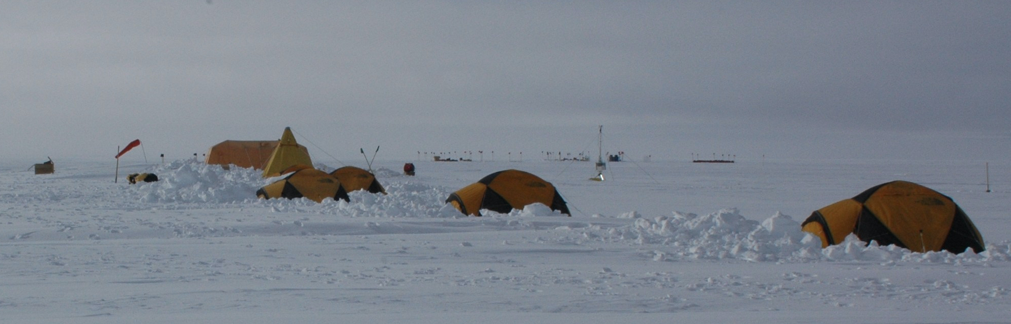
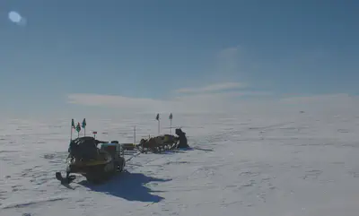
 Tent camp at Hercules Dome
Why Go Back?
They say that the first time you go to Antarctica is for the adventure, the second for the science, and the third because you no longer belong anywhere else. I would hope that it is always for the science, but I do understand how people get attached to the community down here. Life on the ice is mission oriented; whether for science or support, the team knows what needs to get done and works together to accomplish the task at hand.
If you read my writing last year, you will know that we had some logistical issues with our project at Hercules Dome. In a way, we had to come back to even get a real start. Having said that, it is common for field projects to be spread across multiple seasons, and some of our team will be coming down next year as well. I want to give somewhat of an explanation for why any field-based project would need more than one season on the ice.
Logistical Reasons to Return
The first and perhaps most obvious reason that we come back is that there is simply too much work to do in the short Antarctic summer. The only working months for deep field projects in Antarctica are late-November, December, and January. After accounting for some bad weather days, time on the front and back end to move cargo around and test equipment, and expected flight delays, there is not much time left to do the work.
At Hercules Dome, our original plan was to have two field seasons over which to spread the surveying that we had planned, the ’18-’19 and the ’19-’20 austral summers. For each, we planned ~20-30 dedicated science days with a small team of 6-7 personnel in an isolated field camp. Last year, a decision was made early in the season that the surface conditions were too rough at our field site to land the LC-130-Hercules (‘Herc’) which is the Air National Guard plane that we needed to bring in our cargo. Based on that decision, our contingency was to do day trips from South Pole Station using the Twin Otter (a much smaller aircraft). Our total number of science days at Hercules Dome last year amounted to ~2.5, so we obviously did not get done all of what we were hoping for. Fortunately, NSF agreed to fund us for an additional season (‘20-‘21) because of these logistical setbacks.
Even with our limited success, the radar data that we were able to collect last year were instrumental in starting to understand the dome and in our survey planning for this season. Coming into this season, we were able to place a 4-person ground crew in the field in late November to groom a skiway for the Herc to land on. The grooming equipment is a 500-lb frame with adjustable metal tines that plow the snow. We have been calling it a ‘glorified pneumatic rake’ which is dragged behind a snowmobile, essentially amounting to carving out a patch of the ice sheet with a lawn-mower . On December 22nd, the plane landed with ~13,000 pounds of cargo. Then, on December 26th the remaining crew (including myself) landed at Hercules Dome and our science could begin.
Scientific Reasons to Return
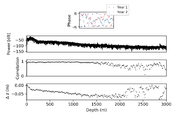
Interestingly, our science also necessitates that we return to complete our measurements of ice motion. Ice moves slowly, especially at an ice divide or an ice dome like Hercules Dome, so we need to wait a considerable amount of time before we can return to measure how far it has moved. For horizontal motion, we use precision GPS instruments at the ice surface which give us a static location at one point in time. Leaving a surveying marker in the snow, we can return the following year to repeat the GPS measurement and learn how far it has moved in the horizontal direction. For vertical motion, we use a special phase-coherent radar instrument. This instrument is similar to our other ice-penetrating radar systems, but with a critical difference that it records phase information from the wave alongside the conventional measurement of wave amplitude through time.
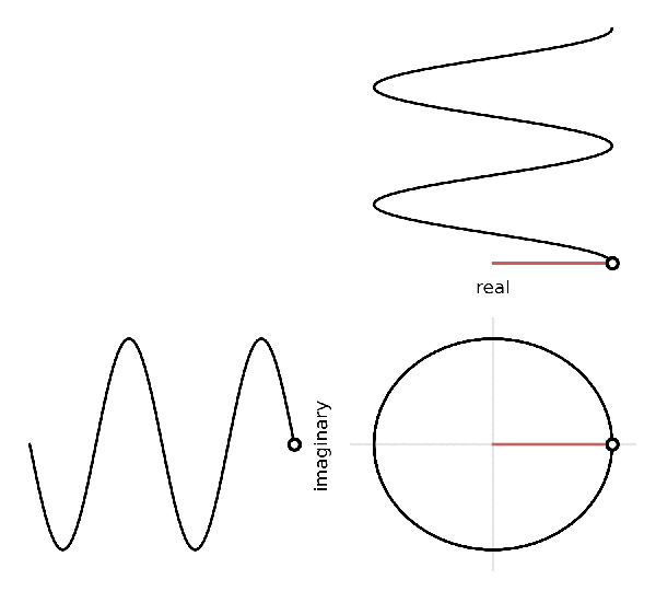
Knowing why a phase measurement can be useful warrants another short physics lesson. There are three components to any wave, the frequency is how long it takes for a 2-pi period of the wave to pass, the amplitude is a measure of the real ‘strength’ of the signal, and the phase is the time-varying location of the wave within its periodic cycle. The animation above shows a waveform as represented in the complex plane. Looking at the circle, the phase of the waveform is represented by the angle that the rotating line makes with the horizontal; hence, the phase repeats itself every time the moving point completes the circle (i.e. at 2 pi). While the power (i.e. the radius of the circle) remains constant in time, the real component fluctuates. With a conventional radar system, we would only measure the real component of the waveform, so there is no way to know the phase. However, with a phase-coherent radar system, we use information that we know about the transmitted waveform to back out the imaginary component as well and can then know the phase with precision to ~1 degree. With a center frequency of 300 MHz, the 1-degree precision allows us to measure vertical ice motion on the order of mm.
In the field, we are using a newly developed phase-sensitive radar system from the British Antarctic Survey known as the ApRES (Autonomous phase-sensitive Radio Echo Sounder). We use this system to measure vertical motion through the entire ice column using a series of impurity contrasts within the ice that cause reflections that we can observe. Since the impurity contrasts move with the ice, we can observe their movement. We were able to make a few ApRES measurements last year, so we have confirmation with our repeated measurements this year that the instrument is working. Having more time on the ground this season, we were able to collect 50 of these ApRES measurements. In the case that we are able to repeat them all next season, we will have a good idea of vertical motion over much of the dome.
Continuous Delays
As of now, we are still waiting for a plane to take us off continent. The delays have been frustrating this year, not only for us, but for all of the deep field groups. For the most part, these delays have been inevitable. Early in the season, weather in West Antarctica created unsuitable flying conditions through late November and early December which is when most groups are trying to get out into the field. Additionally, we are short on LC-130’s and there was an early mechanical issue with the C-17 that set all the cargo movement behind starting in November. The delays on the way out have been a combination of mechanical and weather-related as well. By far our closest attempt to escape was on Saturday, my birthday. That day, we had a 10-hour trip out to the skifield here in McMurdo to watch the C-17 fly in from Christchurch, load our cargo, and then be told that the plane is now broken and will sit on the ground while wait to get a decision from Boeing on whether or not it can be flown. At around 10pm the no-fly decision was made. Lucky for us, they brought out food to tide us over during our long wait (i.e. hot dogs with no bun, utensils, or condiments…).